Posts

Showing posts from 2009

Driving in Okinawa

Image
As promised on my last post, this one is going to deal with driving on Okinawa. Driving has been one of the things that makes my travels so much fun. Sometimes even getting to a destination is an adventure in of its self! First off, they drive on the left side of the road. So the cars here have the steering wheel on the opposite side of the car from what I am used to. I still find myself getting into my car, and finding the steering wheel in front of me! Driving on the left side of the road took some getting used to. The trick I use to ensure I stay on the proper side of the road is, "driver's body to the road center." Road surfaces out here are different than in the States as well. Here the roads are paved with crushed coral instead of gravel. So the littlest amount of rain makes the roads slick. Because of this, on areas where traction is necessary, steep hills and sharp curves, they add a rubber type compound to the coral. This compound turns the coral red.

The Story So Far: Part 4

Image
This is the last of my "catch-up" posts. The day after I went out to Zanpa Point, I got bored. The laundry was done, the room cleaned, and the sun was shining bright. So I decided to drive and see what I could see. So I hopped into the car and drove out on the base's gates. Not even a mile outside of base, I saw a sign that gave directions to another gusuku . So I turned down that road. The sign said that the castle was down the road about 2.4km (1.5 miles). After driving the appropriate distance, I did not see the castle, so I stopped at a Lawson, which is an Okinawan version of a Seven Eleven, to get a map and some directions. I ended up spending 2000Y ($22.41) on an awesome road atlas. It is one of those that shows all the roads, including some that are no longer there. I thought, "Great, I have an atlas. I can figure out were I am at, and find the roads to get me to where I want to be." One problem though, the atlas is completely in Japanese (do

The Story So Far: Part 3

Image
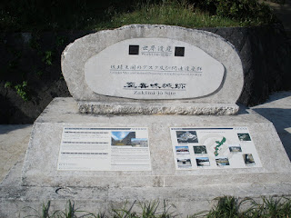
Now that I felt confident driving on the left side of the road, I decided to go even farther afield from Camp Foster. I was talking to a friend of mine, and he suggested that I go check out some old castle ruins. After recieving some vague directions, (get on 58 to Kadena, and you will see signs....you can't miss it!) I filled up the car with gas, and took off. I managed to find the castle ruins, but I had to have nerves of steel to get there. You see, the road leading up the hill to the castle was twisty-turny and two lane in name only. After a couple of minor scares, I found myself at the parking lot. Boy was I in for a suprise. Just a little background information on the castles here in Okinawa. These castles are called gusukus . These gusukus were built during the early 1400's. At this time, Okinawa was divided into 3 kingdoms that were not on speaking terms. The central kingdom, Chūzan conquered the other two kingdoms and form the Ryūkyū Kingdom. This kingdom

The Story So Far: Part 2

Image
After that first weekend in Naha, I decided to take a break. So I did not go anywhere for a couple of weekends. On 30 October, a dangerous thing happened. It is so dangerous, that no one is safe either on base or off. I received my SOFA Driver's license. I passed the test on the first try, and then proceeded to go look for a car. I found one the next day. It is a blue 2000 Mazda Demio, similar to the picture at start of this post. It has an automatic transmission, power windows, power locks, AM/FM CD, styling 13-inch wheels, and a 1.3L four cylinder 82hp engine that would make a riding lawnmower proud. Ok, so it gets great mileage, but MOTORCYCLES have larger engines than this car. I should not complain though, it is perfect for the smaller roads out here. Speaking of the roads out here, I had to make a minor adjustment in my driving style. I had to remember to drive on the LEFT side of the road! So after I first got my car, I only drove on base. This way, if I made a

The Story So Far: Part 1

Image
I need to do some catching up, so these first couple of posts are from when I first got on Okinawa. I arrived here in the afternoon of 9 October, 2009, after a 23 hour flight. I immediately went to bed in my room at the Barracks. The next morning, a friend of mine woke me up at 9am. "Let's go to Naha, and see the Tug-of-War Festival!" So we left and drove the 12 miles to Naha. The festival was crazy. There were street vendors galore and massive amounts of people. They had shut down the main intersection of Naha for this festival. You see, Naha is not a small town. I think the population is the same as Washington DC. So when they shut down this intersection, no cars were going anywhere. One team was on one side of the intersection, and the other team was across from them. In the middle was this huge knot with a big ball above it. The team who pulled the knot to their side of the intersection wins the contest. As these teams are tugging against each other, the

Map of travels so far

I sat down with Google Maps and my notes, and created a map of where I have gone so far on Okinawa. Whenever I post an update, I will also update the map. The link to this map will always be at the end of my posts. Enjoy! The Okinawa Expedition

Greetings to everyone

Rather than fill up your e-mail in boxes with pictures, I decided to start a blog. I will update this with pictures and commentaries about the sites that I see and places that I go. I hope you enjoy reading about my "Expeditions" as much as I had conducting them.